GPT Image 2AI 提示词
Satellite Anomaly Interface — Sora 2 Prompt
Create a realistic satellite imagery mockup with a mysterious geometric anomaly, interactive timeline, and professional NOAA-style UI controls.
提示词 · EN
type
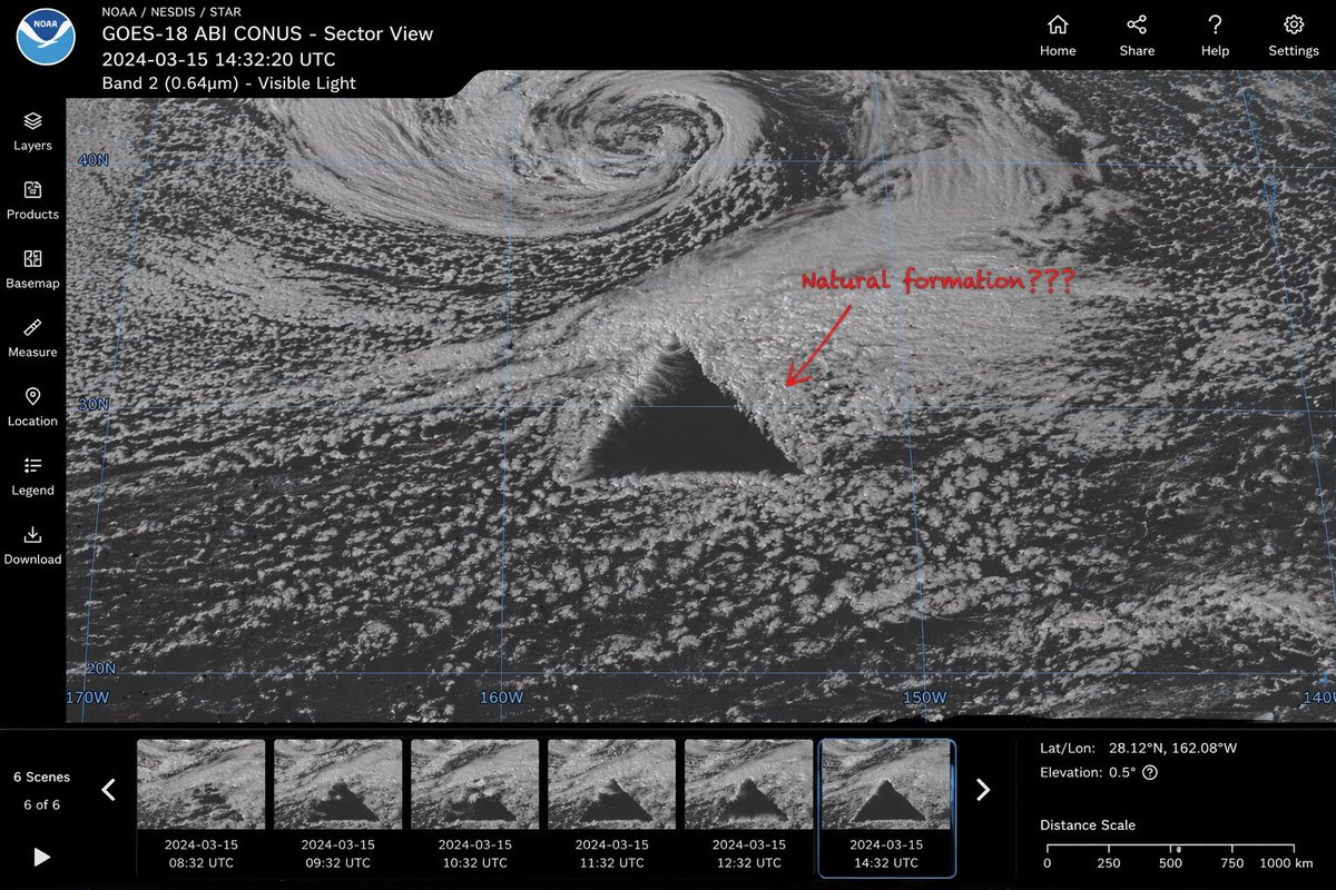
satellite imagery web interface mockupmain_display
imagery
greyscale satellite view of ocean clouds featuring a {argument name="anomaly shape" default="massive, perfectly geometric dark triangle"} in the centerannotation
red handwritten text '{argument name="annotation text" default="Natural formation???"}' with a red arrow pointing to the anomalyoverlay
faint blue latitude and longitude grid lines with coordinate labels like 40N, 30N, 160Wui_layout
top_header
left_section
NOAA logo, text '{argument name="satellite name" default="GOES-18 ABI CONUS - Sector View"}', '{argument name="timestamp" default="2024-03-15 14:32:20 UTC"}', and 'Band 2 (0.64µm) - Visible Light'right_section
4 navigation icons with labels: Home, Share, Help, Settingsleft_sidebar
count
7items
item 1
Layersitem 2
Productsitem 3
Basemapitem 4
Measureitem 5
Locationitem 6
Legenditem 7
Downloadbottom_panel
timeline
controls
Play button, left/right arrows, text '6 Scenes', '6 of 6'thumbnails
count
6description
sequential satellite images showing the anomaly's progression, with hourly timestamps from 08:32 UTC to 14:32 UTCdata_readout
coordinates
{argument name="coordinate text" default="Lat/Lon: 28.12°N, 162.08°W"}elevation
Elevation: 0.5°scale
Distance Scale bar from 0 to 1000 km关于这个提示词
Create a realistic satellite imagery mockup with a mysterious geometric anomaly, interactive timeline, and professional NOAA-style UI controls. 它更适合作为 GPT Image 2 的概念艺术起点:先保留画面结构、主体关系和风格约束,再替换成你的品牌、人物或场景。
这条提示词使用结构化 JSON 组织信息,包含 type、main display、ui layout 等字段。保留这种层级能让模型更清楚地区分画面主题、布局、界面元素和细节约束。
使用时建议先小幅修改主体、场景、镜头和色调,再生成多个版本对比构图与细节。这样页面内容对用户有实际帮助,也避免把模型名或标签机械堆在正文里。
如何使用这个提示词
- Copy the prompt into your chosen AI image generator.
- Select a model like Sora 2 or similar for photorealistic results.
- Customize the
{anomaly shape},{annotation text}, or{satellite name}arguments to match your vision. - Generate the image and refine the variables for different scenarios.