GPT Image 2AI Prompt
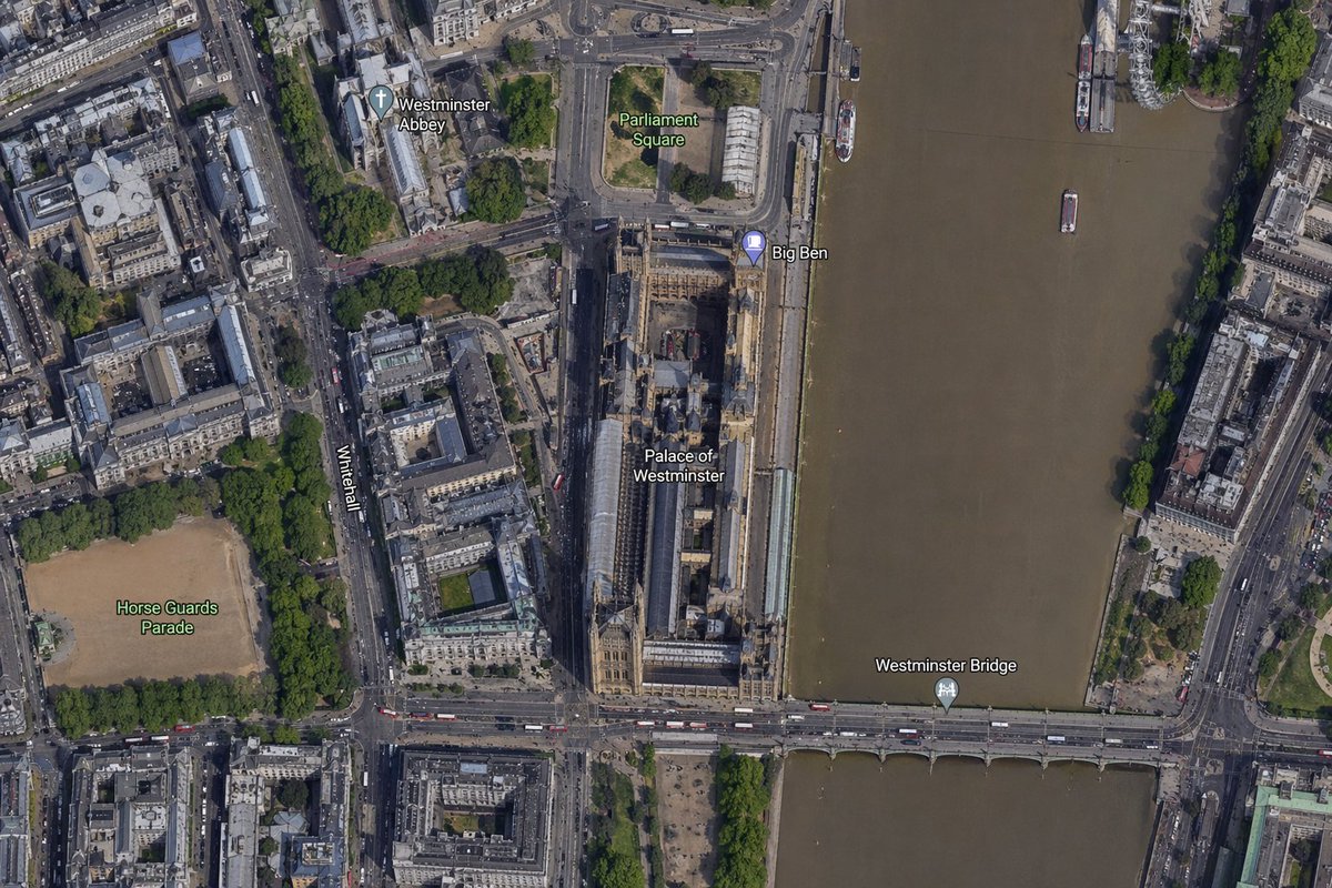
Satellite Map: Big Ben & Westminster Labels — Sora 2 Prompt
Generate customizable, labeled satellite maps of any city's landmarks—perfect for realistic geographic visuals and AI art.
PROMPT · EN
一张以 argcity: 伦敦 市中心为核心的高分辨率俯视卫星地图,紧密聚焦于 arglandmark: 大本钟 及泰晤士河畔威斯敏斯特宫周边区域。呈现出现代数字地图或卫星图层般的逼真航拍正射视角,包含详细的屋顶、街道、树木、阴影及棕褐色的河水。将长条形的威斯敏斯特宫建筑群垂直放置在画面中右侧,紧邻河流西岸,大本钟位于宫殿东北角靠近河岸的位置。一座标注为 argbridge name: 威斯敏斯特桥 的桥梁在画面底部从左至右横跨河流。总共包含 6 个可见地图标签:arglabel 1: 威斯敏斯特教堂、arglabel 2: 议会广场、大本钟、威斯敏斯特宫、威斯敏斯特桥和骑兵卫队阅兵场。同时将白厅作为一条标注道路,垂直显示在宫殿区域左侧。周边细节应包括左上象限的威斯敏斯特教堂、宫殿上方的议会广场、左下象限作为大型沙色长方形场地的骑兵卫队阅兵场、左半部分密集的城市街区与道路、占据整个右侧的泰晤士河、两岸的堤岸、河上的少量船只以及绿树成荫的街道与公园。采用自然的卫星图像色彩、清晰的地图标注叠加层,呈现出放大后的在线地图截图效果。
About this prompt
Generate customizable, labeled satellite maps of any city's landmarks—perfect for realistic geographic visuals and AI art. Use it as a Concept Art starting point for GPT Image 2: keep the visual structure and style constraints intact, then swap in your own subject, brand, or scene.
Start by replacing city, landmark, bridge name, and label 1, then keep the camera, composition, and material cues in the same order. This makes the output easier to compare across variations.
How to use this prompt
- Copy the provided prompt into your AI image generation tool (e.g., Sora 2).
- Replace the variables like
{city},{landmark}, and{bridge name}with your own values. - Choose a model that excels at realistic, map-style visuals (e.g., high-resolution satellite imagery).
- Run the prompt and review the output; adjust label positions or details if necessary.
- Save or download your customized annotated satellite map.